
Dedicated to the citizens of Mason County, Washington since 1886
Dedicated to the citizens of Mason County, Washington since 1886
First, find your reference peak
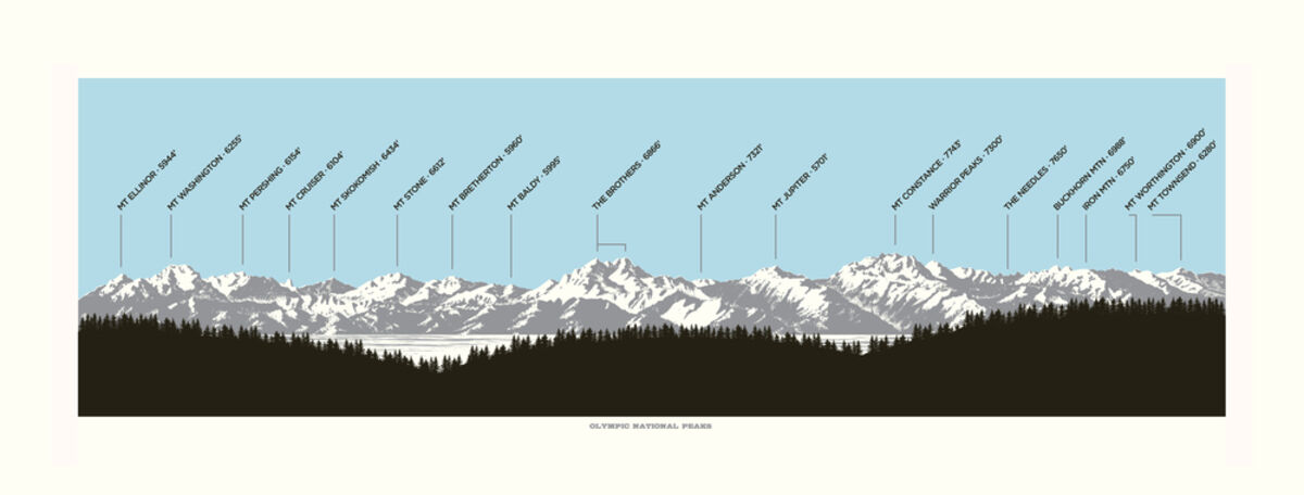
This illustration, looking west, shows the peaks and heights of many of the Olympic Mountains.
On a sunny afternoon in early May, I was at the Olympic Gateway Center up the hill from downtown Shelton. From the parking lot, you could see an immense, snow-covered, hulking presence to the north.
I entered The Shopper and asked a woman inside if she'd mind coming outside to look at something. We walked out to the parking lot and I pointed to that mountain.
"You know the name of that mountain?" I asked her.
"I'm not sure," she said. "Mount Rainier?"
"No," because I knew that for sure. I turned and pointed east. "Mount Rainier is that direction."
"Is that the Cascades or the Olympics?" she asked. She was new to the area.
Another person approached, a woman who looked to be in her 60s.
"Do you know the name of that mountain?" I asked, pointing again.
"No," she said. Then she laughed. "But I've only lived here all my life."
Two weeks ago, I directed the mountain question to a woman on the dock at Hood Canal Marina in Union. "Oh, I should, but I don't," she said, adding that she's been in the area for 20 years.
I also was uncertain of the name of that mountain seen from the dock in Union - and the mountain seen from Shelton, which might have been the very same mountain. My question to all three women was to lead us to a fact, not to highlight how ignorant people are of Western Washington toponymy.
For the past three weeks, I've been considering that mountain. I've looked at maps online, I've taken pictures of the Olympics and run them through the PeakFinder app, I've talked to people whose business requires that they know the names of Olympic peaks, I've visited vistas from Olympia to Union to the Seattle neighborhood of Ballard. I've risen at 5 a.m. to see the Olympics at sunrise and watched the mountains at sunset.
After all that, my best guess is this: That immense, snow-covered hulk is Mount Washington. Probably. I'm also reasonably sure that the mountain you see through the slot of northbound U.S. Highway 101 starting near the Skyline Drive-In Theater is also Mount Washington.
For most Mason and Thurston County observers, Mount Washington is the most prominent peak along the eastern edge of the Olympic Mountains. Mount Washington is about 6,250 feet high and is recognizable much of the year by the snowless, vertical stripe that starts not far below the summit, and by its broad, somewhat symmetrical girth.
Old-timers sometimes refer to the image created by that snowless crease as "The Traveler."
Mount Washington is the third tallest peak in Mason County, behind Mount Stone and Mount Skokomish, but because Mount Washington is the farthest east of the three, it stands out, like the lead singer in a band. The summit of Mount Washington is due west of where the Hamma Hamma River flows into Hood Canal, near Mason County's border with Jefferson County.
Sounds easy enough to pick out Mount Washington? Right?
Wrong.
The problem with identifying Olympic peaks is they're too many and too packed. The Olympics stretch approximately from Brinnon in the east to Forks in the west and from Quinault in the south to Port Angeles in the north. That's 75 miles of crammed mountains from north to south and from east to west.
That's more than 5,600 square miles of mountain, twice the size of Delaware, which many of us know as a state. According to PeakVisor, another mountain identification app, 244 named mountains are in the Olympics, including 43 in Mason County.
Many Western Washingtonians want to learn these mountains' names. When I asked readers in March to pick from among 19 possible column topics, learning to identify peaks in the Olympics came in first, twice as many as the second choice. It seems people feel derelict about not knowing our mountains' names, similar to the feeling of not knowing your neighbors' names.
Another draw might be this: Being able to attach a name to a thing brings that thing closer to us. It makes it more familiar. For instance, there must have been a time in human existence when what we now call "birds" were called something else, maybe "sky movers."
Our language progressed and "sky movers" became "birds." We progressed further, developing ways to distinguish this bird from that bird, allowing us to make statements like, "Those crows sure are smart" or "That scrub jay is driving me nuts."
If we know the name of a particular Olympics peak, we're then able to tell a friend, "The sunlight on Copper Mountain is especially beautiful today." It enriches our interaction with the material world, and each other.
This Olympic-sized peak-identification problem stems from the Olympics being less range and more "clump," which is how illustrator and Everett resident Elizabeth Person described it. Person makes a living creating "informational art," including water-color depictions of the Washington Cascades, the Oregon Cascades and her best-selling work, a peak-labeled illustration of prominent features of the Olympic Mountains stretching from Mount Ellinor in Mason County to Hurricane Ridge in Clallam County.
Even Person, whose livelihood depends on being accurate and who spends much time staring at mountains, admits she's often unsure of the name of the Olympic peak she's looking at.
"No, I wouldn't be that confident," she said when I asked whether she could look at the Olympics and identify the peaks. "I guess The Brothers I could, but because the Olympics are such a dense range, it's like a square of mountains. It's different than the Cascades because they're long and skinny. Because The Brothers have a little space around them, they're easiest for me to identify. Other than that, maybe Mount Constance, but that depends on what angle I'm seeing it at."
Perspective, the season, light, snow cover and distance all play roles in making identifying the Olympics fuzzy, like trying to identify someone at a high school reunion after 40 years. It's not like the certainty you have when you're looking at, say, the Mona Lisa. You know it's her.
For instance, I've seen what I suspect is Mount Washington from the Capitol Campus in Olympia when it looks maybe 50 miles away. Then I walked a mile east of that campus vista and Mount Washington looked 100 miles away.
Explain that one.
"I did it from multiple reference points," Person said of her Olympics print. "I always use Google Earth, I look at the national park maps of that area to identify peaks. I look at old drawings. It's kind of a combination of items. A lot of my mountain ranges, for example my Cascades range, are hypothetical because the Earth curves. You couldn't see all those peaks from one vantage. But the Olympics is a realistic view. You can actually see all those peaks.
"I do use a fact-checker now, but with the peaks, I'm just very careful, and honestly sometimes I've made a few updates for this print based on errors that people have caught," she said. "It's imperfect. I wouldn't say this is 100% accurate. My biggest wholesale partner is Metsker Maps, a map shop in downtown Seattle near Pike Place. Their staff is incredible. They have caught a few of my errors because they're map geeks. I feel pretty confident about the accuracy of the things now."
Because Person lives in Everett, she uses The Brothers, elevation 6,866, as her Olympics' reference mountain. The Brothers is straight west of Ballard. Mike Klay, who designed the print of the Olympics shown in this column, lives in Seattle and said he also uses The Brothers as a reference point.
So ... here's how to identify peaks in the Olympics: First, pick a reference mountain - the people I've talked to use Mount Washington or The Brothers. Second, learn to pick out your reference mountain from any distance, any perspective, during any season and during any time of day. Once you've got your home peak down, move to the sides. You can pick out Mount Ellinor as the sharp-beaked peak to the left of Mount Washington. Mount Pershing is the little toe of a peak to the right of Mount Washington.
It's like learning a language, one mountain at a time.
Shelton-Mason County Journal & Belfair Herald
email: kirk@masoncounty.com


Reader Comments(0)